Mapping as a forestry management tool
Information technology plays a dominant role in today’s professional world. Forest management is no exception with, for example, mapping which can provide a broad array of services.
Today’s forest managers are fully versed in the latest technologies and make increasing use of IT in their job, where IGN (from the French national geography and forestry institute) data is particularly useful.
When studying a forest, the first task is often to analyze it on a workstation:
- Looking at the Scan25 topographic map to identify access to the forest, its relief and any water courses that cross it.
- Perhaps looking at the land register to find out whether a track is public or private, and to find out the size of the survey plots that make up the forest.
- Looking at an aerial photograph to identify homogenous areas, and get an idea of the proportion of conifers, deciduous trees and young plantations. For example, we can make out windthrow areas (areas where trees have fallen, usually due to the wind).
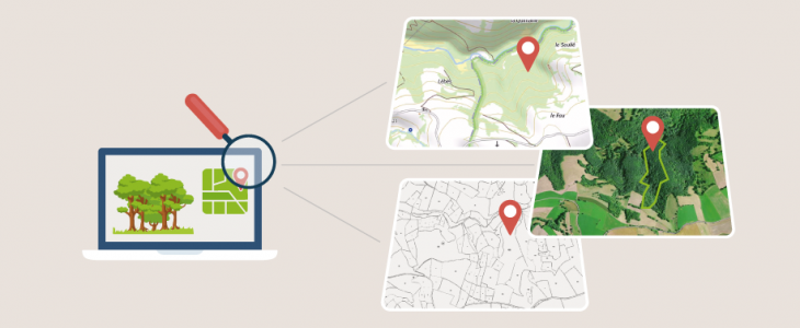
Topographic maps, land register extracts and aerial views all provide valuable information on the forest’s characteristics
This study is especially useful when appraising a forest or drawing up a forest management plan (the ‘PSG’ or ‘plan simple de gestion’ is an official requirement in France) which includes a written document and a detailed map showing the forest’s characteristics as far as possible, the surface area of each plot and the different stands. Work in the field remains essential for confirming and refining the assumptions made when interpreting the images.
Computerized mapping is a now a vital tool, helping to save time and produce high-quality documentation.
This map is very useful as a management document but also key to understanding forest management. I think the expression ‘a picture often speaks louder than words’ is very applicable in this case!